For LICENCE Information please see: LICENCE: ICAO FIR LICENCE AGREEMENT
Go to the Demo page to see the structure of the ICAO FIR Fields attribute

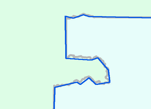
Precision for the boundary (limit of the
country) in the FIR files,
The creation of an FIR are made with
coordinate normally and when the description of that FIR follow the country
boundary we follow the Digital chart of the world with reduce point at the beginning, because at
that time the computer are not enough strong to take all the points, so the
precision for the line following the country boundary are not full precise but
a good representation of the reality, with the version ICAO FIR 2014 some country boundary are from ESRI shape file country 2008 (25 meg) much better then before, with the version ICAO FIR 2020 some country boundary are from United Nation in New York 2012 shape file. Soon with the version ICAO FIR 2020 we take the some boundary from Global_LSIB_Lines_Simplified_2019:
Now we replace all the country Boundaries with the the Best data available for boundaries from DATA.GOV:
Global_LSIB_Lines_Simplified_2019
Global_LSIB_Lines_Simplified_2019 for her lines representing the Country Boundaries, when in the Amendment we have “Following Border”.
Believed to be the most accurate available worldwide international boundary vector line file.
The precision is better than other sources…
Google and Open Street Map selected that vector files for our Base Map…
Work flow for the FIR files
Discussion about the creation of the FIR data base: The ICAO FIR are made with official ANP amendments (regional air navigation agreement) that take more time for the Official anwser, so sometime the AIP from State has already the change before ICAO, conclusion to follow all the change faster, we create two files to send to you; the ICAO FIR Official (approuve by the conseil) and an other one ICAO FIR FORESEEN UPDATE (ICAO FIR MISE A JOUR PREVUES) following many sources to verification for quality control.
I believe that the eANP WG assumed that the Information that was held by HQ in terms of the FIR and SRR boundaries came from ANP amendments over the years (i.e.: as a result of regional air navigation agreements at things like Regional Air Navigation meetings). If in fact the data has been amended by using AIP Information from States like I think you described for Chennai then that could be a major problem, as AIP Information is quite often different between States and is not subject to regional air navigation agreement as required by Annex 11. So we must find a better work flow to correct that situation
We are presently working to insert all the UN boundary in our ICAO FIR shape file.
DATA SOURCES & DISCLAIMER:
DESIGNATIONS USED: The depiction and use of FIR delimitation, boundaries names, related data shown on maps and included in the dbf from the shape file format are not warranted to be error free (98% good) nor do they necessarily imply official endorsement or acceptance by the ICAO part of United Nations.
COPYRIGHT NOTICE: Unless otherwise nare produced by the Cartographic Section and are copyrighted by the ICAO part of United Nations. Reproduction of any part without the permission of the copyright owner is unlawful.
LINKS TO OTHER WEB SITES: This is the ICAO cartographic section: Links to other sites are provided for Information only. The inclusion of these links and their content does not imply official endorsement or approval whatsoever by the ICAO or United Nations.
For additional Information please seeLICENCE: ICAO FIR shape file LICENCE AGREEMENT
For additional Information please see ICAO MAP DISCLAIMER
Please contact us for any
questions regarding publication permissions. ICAO MAP DISCLAIMER
© ICAO
